
Little Presque Isle after dark with the moonlight shining.
Little Presque Isle Recreation Area
ByMikel B. Classen
North of Marquette, in Michigan’s Upper Peninsula, there is a place for all seasons and things. Sound almost too good to be true? Nestled in the foothills of Lake Superior’s Huron Mountain range, the Little Presque Isle Recreation Area has virtually everything that someone would want when going outdoors. Backtrail hiking, fishing, hunting, cross-country skiing, snowmobiling, swimming, rock climbing, or simply a treat for the senses, this place has it all. A quick drive 5 miles north of Marquette, on County Road 550 will get you there. The area is little used, though it has been well known to local residents for years.
This is a section that the Michigan State Department of Natural Resources developed for recreational activities and spent well over a quarter of a million dollars completing it. Trails are groomed, marked and kept, while the streams and lake is already well stocked. This is a most enjoyable area to visit and because of its diversity, countless hours can be spent there doing a variety of activities year round.
There are 5 basic locations that outdoors activities can revolve around that make up the area. None any of them cost more than the time and effort it takes to enjoy them. The 5 locations are: Sugarloaf Mountain, Hogsback Mountain, Wetmore’s Landing, Harlow Lake, and Little Presque Isle.
SUGARLOAF MOUNTAIN:
This is a very popular spot for Marquette residents and its visitors. Its well-marked parking lot makes it easy to find. The entry is located not quite 4 miles north of Marquette. The trail to the top of the mountain is well marked and well kept. Where the going gets steep there are hand railed stairways built which makes climbing easy and reasonably pleasant.
Also, benches are placed for an occasional breather if the need arises. This is a nice climb summer or winter and in winter there are extra treats on the way up. Coming out of the rock outcroppings are small running springs or water seepages. These run constantly and in the freezing of winter can build some wonderful and sometimes colored icicle formations that continually grow throughout the winter. When one reaches the summit, miles of view is waiting of Lake Superior, Marquette, Little Presque Isle. All of the surrounding area including that of nearby Hogsback Mountain.

Hogsback Mountain looms over Harlow Lake at the recreation area.
HOGSBACK MOUNTAIN:
The trail for this is 1 mile north of Sugarloaf’s parking lot and on the opposite side of the road. It is marked as the Harlow Lake Trail but it also serves as Hogback’s. This is a lengthy and at times strenuous walk making it necessary to be in reasonably good physical shape. There are no stairs or any climbing aid other than a marked trail. It is some work to reach the top. The trail starts out as an old two rut trail that goes back to an abandoned railroad grade. Here trails split.
Follow the railroad grade to the left. If you go to the right you are on the Harlow Lake trail which is an excellent hiking and skiing trail. Straight ahead trails wander into the woods in a maze that if one doesn’t know them, getting lost is a good possibility, but by the same token, if you can learn them then a lifetime of exploring by skiing, hiking, or snowmobiling is possible. Follow the trail to the left for a couple of hundred yards where a footpath runs into the woods to the right.
There will be large painted spots on the trees marking the trail. Follow it and the summit is about 30 minutes away. The true enjoyment of this trail comes from traveling through a deep mix of hardwood and pine decorated by massive rock outcrops. Wildlife can be frequently seen on the trail. The higher degree of difficulty in the climb can be very self-satisfying and another attraction of this walk is solitude.
Where Sugarloaf has a good deal of traffic on it, other hikers on Hogsback are few and far between if any at all. The view from the summit is somewhat different than that of Sugarloaf because of its positioning and the fact that it is a couple of hundred feet higher. Harlow Lake and some other surrounding wetlands are visible that cannot be seen from Sugarloaf. All in all it is an excellent hike of about 4 miles round trip.

Harlow creek runs between the lake and Lake Superior. It is beautiful in winter.
WETMORE’S LANDING:
The entrance to this is directly across the road from that of Hogsback. This is a cove with one of the finest sheltered beaches around. This is a pocket of pleasure that is surrounded by rock and cliffs. The cliffs are similar to those that make up Pictured Rocks National Lakeshore but on a smaller scale.
There are hiking trails that run from here to Sugarloaf which affords some spectacular shoreline scenery. Snowshoeing the trail in the winter is like entering another world. Hanging snow, ice covered shrubs and trees from the waves crashing, dozens of hanging ice formations from free flowing water and springs, and the heavily sheltered shoreline from prevailing winds all makes for unique winter snowshoeing.
Running the other direction, a trail goes to Little Presque Isle. This will take you up and onto the top of cliffs that are almost copies to those that make up Pictured Rocks. It takes the hiker or snowshoer up for some wonderful views of Lake Superior and the incredible shoreline that makes up the area. Wetmore’s Landing is also one of the best swimming and picnic spots available especially because of its sheltered nature.

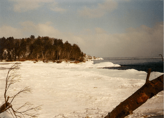
Little Presque Isle is a favorite spot for locals in the summer.
LITTLE PRESQUE ISLE:
The entrance to this is 1.2 miles north of Wetmore’s Landing on the same side of the road. The entrance is just a few feet south of Harlow creek. This is another of the favorites of locals. Here there is an extensive beach and Little Presque Isle is quite a sight. It stands off-shore and a shallow sand bar connects it to the mainland. In the summer it’s a shallow wade over to the island through Lake Superior and in winter, Little Presque Isle’s connected by a wide ice bridge. Many come here to camp or view the rock formations that not only make up a good portion of the island, but also make up much of the shoreline.
In the winter, after a good east-northeast storm, Little Presque Isle and the surrounding shoreline will become literally encased in ice. It makes for rare photography, excellent viewing when skiing or snowshoeing, or simply a winter walk. Picnickers should always get supplies before they leave Marquette because there are no stores along the road.
HARLOW LAKE:
The entrance to this is directly across County Road 550 from Little Presque Isle. A couple of days here can be very rewarding. Scenically it is beautiful with Hogsback Mountain always standing over it in the distance. It also holds habitat for many diverse species of wildlife including many that are rare and endangered. Eagles hunting the lake is not unusual. The lake holds many different kinds of fish from panfish to Pike to Trout and is fed by three fast moving cold water streams which hold Brook and Rainbow Trout. These are easily accessible and quite productive.
This place is already a playground for skiers, hikers, snowmobilers (literally miles of trails branch off from Harlow Lake). Fishing and ice fishing, boating, canoeing, or just relaxing in the pines sitting on one of the immense granite rocks that are exposed in several places on the lake. Rustic campsites are here and a public access for boats already exists though they accommodate small craft only. One-room, fully equipped cabins have been built. These are not free and can be rented by contacting the Marquette, Michigan DNR office or visiting the DNR website.
As I have said there is no place like this one for year around recreational fun. If a trip to Michigan’s Upper Peninsula is in the plans, then the Little Presque Isle Recreation area should be a part of them.
For more information on Little Presque Isle, visit these websites:
https://www2.dnr.state.mi.us/parksandtrails/details.aspx?id=698&type=SFCG
Click to access little_presque_isle_harlow_lake.pdf
https://www.michigan.gov/dnr/0,4570,7-350-79133_79200_31427-54018–,00.html
Little Presque Isle is a favorite spot for locals in the summer.
Back to the Features Page
Back to the Mikel B. Classen homepage
Content copyright . Mikel Classen. All rights reserved.